Canada FactbookDraft
November 2026 Edition
Canada Factbook · National chapter / CAN
Geography

ⓘ
2021 Factbook flag mirror; image identity has not been individually audited. Source.
Last updated: October 29, 2026
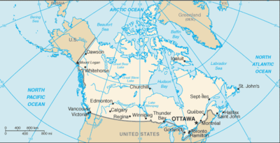
Map image could not be loaded. Open source image.
ⓘ
CIA World Factbook map, February 2021 media edition. Identity reviewed; current boundaries have not been audited. visual contact sheet or original identity check; does not verify current boundaries Boundaries, place names and designations may be dated or disputed; original annotations retained. SHA-256: 956a59a0771cf89600fe11c4d544c80a53a7959e35769872c463b0a709b3fcbe. Provenance and inspection record.ⓘ
World Bank directory coordinates; approximate location, not a country center. Coordinate reference date is not supplied by the directory. Natural Earth 1:110m land (2022 source); simplified coastline, no political borders. Map source. Land SVG SHA-256: CF26056A39DC0A5B02F65704E279DFA86E77539A8387D0B2C92F907A67739E5E.Sections in Geography
- Location
- Geographic coordinates
- Map references
- Area
- Area - comparative
- Land boundaries
- Coastline
- Maritime claims
- Climate
- Terrain
- Elevation
- Natural resources
- Land use
- Irrigated land
- Major lakes (area sq km)
- Major rivers (by length in km)
- Major watersheds (area sq km)
- Major aquifers
- Population distribution
- Natural hazards
- Geography - note
Geography
Location:2
Northern North America, bordering the North Atlantic Ocean on the east, North Pacific Ocean on the west, and the Arctic Ocean on the north, north of the conterminous US
Geographic coordinates:3
60 00 N, 95 00 W
Map references:4
North America
Area:5
Area - comparative:6
slightly larger than the US
Land boundaries:7
Coastline:8
Maritime claims:9
Climate:10
varies from temperate in south to subarctic and arctic in north
Terrain:11
mostly plains with mountains in west, lowlands in southeast
Elevation:12
Natural resources:13
bauxite, iron ore, nickel, zinc, copper, gold, lead, uranium, rare earth elements, molybdenum, potash, diamonds, silver, fish, timber, wildlife, coal, petroleum, natural gas, hydropower
Land use:14
agricultural land:6.5% (2023 est.)
arable land:4.3% (2023 est.)
permanent crops:0% (2023 est.)
permanent pasture:2.1% (2023 est.)
forest:42% (2023 est.)
other:51.4% (2023 est.)
Irrigated land:15
Major lakes (area sq km):16
fresh water lake(s):Huron* - 35,972 sq km; Great Bear Lake - 31,328 sq km; Superior* - 28,754 sq km; Great Slave Lake - 28,568 sq km; Lake Winnipeg - 24,387 sq km; Erie* - 12,776 sq km; Ontario* - 9,790 sq km; Lake Athabasca - 7,935 sq km; Reindeer Lake - 6,650 sq km; Nettilling Lake - 5,542 sq km
fresh water lake(s):note - Great Lakes* area shown as Canadian waters
Major rivers (by length in km):17
Mackenzie - 4,241 km; Yukon river source (shared with the US [m]) - 3,185 km; Saint Lawrence river mouth (shared with US) - 3,058 km; Nelson - 2,570 km; Columbia river source (shared with the US [m]) - 1,953 km; Churchill - 1,600 km; Fraser - 1,368 km; Ottawa - 1,271 km; Athabasca - 1,231 km; North Saskatchewan - 1,220 km; Liard - 1,115 km
note:[s] after country name indicates river source; [m] after country name indicates river mouth
Major watersheds (area sq km):18
Arctic Ocean drainage:Mackenzie (1,706,388 sq km)
Atlantic Ocean drainage:Mississippi* (Gulf of America) (3,202,185 sq km, Canada only 32,000 sq km), Nelson (Hudson Bay) (1,093,141 sq km), Saint Lawrence* (1,049,636 sq km, Canada only 839,200 sq km)
Pacific Ocean drainage:Yukon* (847,620 sq km, Canada only 823,800 sq km), Columbia* (657,501 sq km, Canada only 103,000 sq km)
note:watersheds shared with the US shown with *
Major aquifers:19
Northern Great Plains Aquifer
Population distribution:20
vast majority of the population lives in a discontinuous band within approximately 300 km (186 mi) of the southern border with the United States; the most populated province is Ontario, followed by Quebec and British Columbia
Natural hazards:21
continuous permafrost in north is a serious obstacle to development; cyclonic storms form east of the Rocky Mountains, a result of the mixing of air masses from the Arctic, Pacific, and North American interior, and produce most of the country's rain and snow east of the mountains
volcanism:the vast majority of volcanoes in Western Canada's Coast Mountains remain dormant
Geography - note:22
note 1:second-largest country in the world (after Russia) and largest in the Americas; strategic location between Russia and US via north polar route; approximately 90% of the population is concentrated within 160 km (100 mi) of the US border
note 2:Canada has more fresh water than any other country, and almost 9% of Canadian territory is water; Canada has at least 2 million and possibly over 3 million lakes, more than all other countries combined
Notes & sources
- Location. Reference edition; observation: dates as stated in text. Field last updated: not supplied; profile fallback: 2025-12-05 17:28:40 -0500 (not a field revision date); needs review. Reference source. Edition retrieval date: not supplied (retrieval only). ↩
- Geographic coordinates. Reference edition; observation: dates as stated in text. Field last updated: not supplied; profile fallback: 2025-12-05 17:28:40 -0500 (not a field revision date); needs review. Reference source. Edition retrieval date: not supplied (retrieval only). ↩
- Map references. Reference edition; observation: dates as stated in text. Field last updated: not supplied; profile fallback: 2025-12-05 17:28:40 -0500 (not a field revision date); needs review. Reference source. Edition retrieval date: not supplied (retrieval only). ↩
- Area. Reference edition; observation: dates as stated in text. Field last updated: not supplied; profile fallback: 2025-12-05 17:28:40 -0500 (not a field revision date); needs review. Reference source. Surface area: observation 2024; checked 2026-10-29; held. World Bank World Development Indicators. Not available. Held for review: Substantial difference from the historical archived total; geographic coverage and measurement definitions remain unresolved. The archive field does not state an observation year, so this does not establish a same-year conflict or numerical error. World Bank reported surface area. Historical archive total area. The archived total area has no reference year and territorial coverage may differ from World Bank surface area. World Bank: Not available square kilometers (2024). Reference: 9,984,670 square kilometers. Edition retrieval date: not supplied (retrieval only). ↩
- Area - comparative. Reference edition; observation: dates as stated in text. Field last updated: not supplied; profile fallback: 2025-12-05 17:28:40 -0500 (not a field revision date); needs review. Reference source. Edition retrieval date: not supplied (retrieval only). ↩
- Land boundaries. Reference edition; observation: dates as stated in text. Field last updated: not supplied; profile fallback: 2025-12-05 17:28:40 -0500 (not a field revision date); needs review. Reference source. Edition retrieval date: not supplied (retrieval only). ↩
- Coastline. Reference edition; observation: dates as stated in text. Field last updated: not supplied; profile fallback: 2025-12-05 17:28:40 -0500 (not a field revision date); needs review. Reference source. Edition retrieval date: not supplied (retrieval only). ↩
- Maritime claims. Reference edition; observation: dates as stated in text. Field last updated: not supplied; profile fallback: 2025-12-05 17:28:40 -0500 (not a field revision date); needs review. Reference source. Edition retrieval date: not supplied (retrieval only). ↩
- Climate. Reference edition; observation: dates as stated in text. Field last updated: not supplied; profile fallback: 2025-12-05 17:28:40 -0500 (not a field revision date); needs review. Reference source. Edition retrieval date: not supplied (retrieval only). ↩
- Terrain. Reference edition; observation: dates as stated in text. Field last updated: not supplied; profile fallback: 2025-12-05 17:28:40 -0500 (not a field revision date); needs review. Reference source. Edition retrieval date: not supplied (retrieval only). ↩
- Elevation. Reference edition; observation: dates as stated in text. Field last updated: not supplied; profile fallback: 2025-12-05 17:28:40 -0500 (not a field revision date); needs review. Reference source. Edition retrieval date: not supplied (retrieval only). ↩
- Natural resources. Reference edition; observation: dates as stated in text. Field last updated: not supplied; profile fallback: 2025-12-05 17:28:40 -0500 (not a field revision date); needs review. Reference source. Edition retrieval date: not supplied (retrieval only). ↩
- Land use. Reference edition; observation: dates as stated in text. Field last updated: not supplied; profile fallback: 2025-12-05 17:28:40 -0500 (not a field revision date); needs review. Reference source. Edition retrieval date: not supplied (retrieval only). ↩
- Irrigated land. Reference edition; observation: 2015. Field last updated: not supplied; profile fallback: 2025-12-05 17:28:40 -0500 (not a field revision date); needs review. Reference source. Edition retrieval date: not supplied (retrieval only). ↩
- Major lakes (area sq km). Reference edition; observation: dates as stated in text. Field last updated: not supplied; profile fallback: 2025-12-05 17:28:40 -0500 (not a field revision date); needs review. Reference source. Edition retrieval date: not supplied (retrieval only). ↩
- Major rivers (by length in km). Reference edition; observation: dates as stated in text. Field last updated: not supplied; profile fallback: 2025-12-05 17:28:40 -0500 (not a field revision date); needs review. Reference source. Edition retrieval date: not supplied (retrieval only). ↩
- Major watersheds (area sq km). Reference edition; observation: dates as stated in text. Field last updated: not supplied; profile fallback: 2025-12-05 17:28:40 -0500 (not a field revision date); needs review. Reference source. Edition retrieval date: not supplied (retrieval only). ↩
- Major aquifers. Reference edition; observation: dates as stated in text. Field last updated: not supplied; profile fallback: 2025-12-05 17:28:40 -0500 (not a field revision date); needs review. Reference source. Edition retrieval date: not supplied (retrieval only). ↩
- Population distribution. Reference edition; observation: dates as stated in text. Field last updated: not supplied; profile fallback: 2025-12-05 17:28:40 -0500 (not a field revision date); needs review. Reference source. Edition retrieval date: not supplied (retrieval only). ↩
- Natural hazards. Reference edition; observation: dates as stated in text. Field last updated: not supplied; profile fallback: 2025-12-05 17:28:40 -0500 (not a field revision date); needs review. Reference source. Edition retrieval date: not supplied (retrieval only). ↩
- Geography - note. Reference edition; observation: dates as stated in text. Field last updated: not supplied; profile fallback: 2025-12-05 17:28:40 -0500 (not a field revision date); needs review. Reference source. Edition retrieval date: not supplied (retrieval only). ↩